
From field to file - Not everything that matters can be digitised
After years of working closely with cities and communities, one thing has become increasingly clear: not all knowledge can or should be digitised. Yet much of research and urban planning today proceeds with data that counts when it is documented, cited, and stored in formal systems.
In academic, professional and policy circles, there is a mounting pressure to lean on existing literature, papers reflecting on other papers, temporal datasets, both historical and contemporary can sometimes overshadow the deeply human need for direct, first-hand discovery and innovation. It can limit one’s ability to appreciate the many different layers of reality, where knowledge is validated often when it is written, digitised, and formatted into reports that few beyond “specialists” can fully understand.
What gets left out in this process is the vast body of tacit, lived knowledge held by communities.
Scott (1998) warns against what he calls legibility. The state’s tendency to simplify complex, local realities into standardised, manageable data. In doing so, systems that are rich, adaptive, and deeply contextual are often ignored because they do not fit into neat administrative categories.
This is not theoretical. It is playing out in cities like Ramanagara and Chikkaballapura.
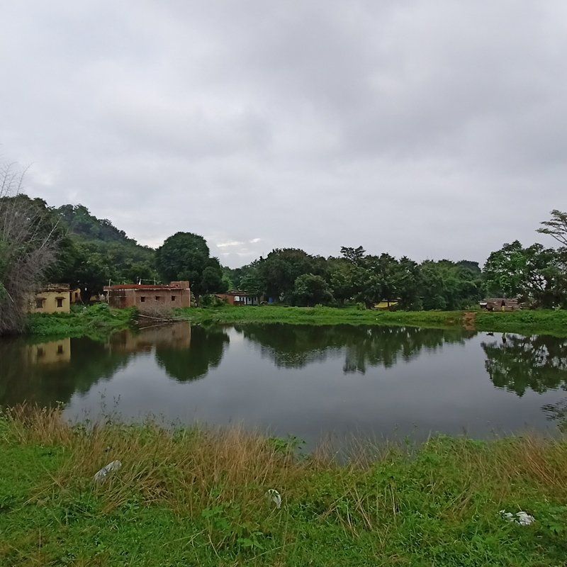
In Ramanagara, while studying water systems around Bolapanahalli kere, I stood at the edge of what any dataset might simply mark as a “water body.” But what unfolded was a living ecosystem. Picturize what I saw: people swimming, a pump house irrigating nearby fields, a farmer recounting stories of his land. On one side stood an abandoned brick kiln; on the other, the steady spread of the town’s built fabric. Further along a mud path, birdlife moved quietly against the backdrop of Ramadevara Betta, while work to strengthen the lake’s bund continued. In a conversation with a young farmer there, one phrase lingered: “e jameen yella namde” (this land belongs to us). “Namde” (ours) did not simply mean ownership. It carried a sense of belonging, belonging of generations who had lived with the land, worked it, and in doing so, become its custodians. Not managers of a resource, but protectors within a relationship that is careful, reciprocal, and deeply rooted.
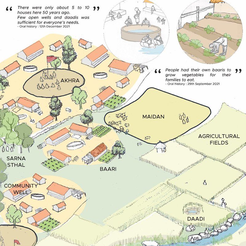
For centuries, such relationships governed natural systems. Communities desilted tanks, shared water, chose crops, and maintained commons. These systems were rarely written down. Referred to as oral histories - these are deeply embedded in memory, practice, and accountability. Roles like that of the neeruganti (village waterman, who was typically a lower-caste man from the village in charge of water distribution and the maintenance of physical water structures (Somashekara Reddy 2007) ensured equitable water distribution; community norms sustained what policy now tries to regulate. Water was not just a resource; it was a social contract.
And yet, this knowledge rarely enters formal planning.
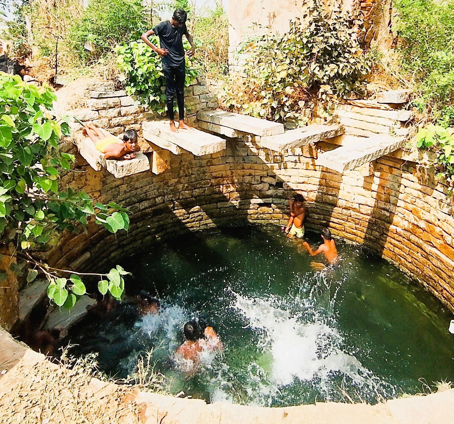
In another interaction in Ramanagara, two farmers spoke about a well, not as an object, but as a living entity. They described how “she” filled through the day, how she served them, and how they, in turn, existed alongside her in a rhythm that felt organised and mutual. When the same well was reduced to a point in a dataset in a presentation to the municipality, the initial response was that of surprise, leading to several questions - Why were they surprised? What did they see and what had they not seen until now?
This gap, between what exists and what is recognised lies, at the heart of the problem.
Urban development is increasingly supported by tools such as geospatial mapping and centralised supply systems. While these approaches appear modern and efficient, they often struggle to capture decentralised, lived ecological and cultural systems that continue to exist on the ground, having sustained communities for generations. As cities expand, trees are cut, land is concretised, wells are sealed or built over - leading to an erasure of traditional systems, both physically and from institutional memory. What remains is the associated tacit knowledge - a highly undervalued dataset. In Chikkaballapura, efforts are underway to revive three
kalyanis
with government funding. Once restored, these will be documented under the Jal Mission Abhiyan requiring local authorities to create a digital inventory by geo-tagging every water body to prevent them from being lost to future construction or encroachment. While this is a laudable policy intervention, in yet another location, a local community, along with a temple trust have begun reviving a
kalyani dating 1902 (Nayak, 2025) that they consider valuable from several dimensions. They are relying on their own resources. This effort, however, remains unrecognised by the municipality because of a mix of bureaucratic inaction, disputed ownership, and political influence
(Nayak, 2025).
What happens then to this “unofficial” water body? Without formal acknowledgment, it risks disappearing again, this time not just physically, but from the records that shape future planning.
Elinor Ostrom’s work has shown that communities can sustainably manage shared resources through locally evolved systems of knowledge and governance. These systems do not always translate into formal data, but they work.
The issue, then, is not digitisation itself. Digitisation, mapping, and formal datasets are, while indispensable to contemporary planning, should not be the only lens through which knowledge is recognised. Documentation and data systems are essential, yet their reliance on sources that are formally recognised risk creating dangerous blind spots.
Scott’s distinction between technical knowledge and metis - Practical, experience-based knowledge that is difficult to formalise but crucial for real-world functioning is a useful lens to bring in the community-knowledge.
Long before tools like Google Maps began guiding us, people navigated memory, repetition, and lived experience. Even today, there is a certain clarity in directions sketched by hand. This becomes even more striking in the story of a farmer displaced by urbanisation in Bengaluru. His mental map holds far more than any formal dataset: water bodies, village gatherings, cultural landmarks, from ashwath katte to grazing lands and wells. Though the village has been renamed, these memories persist, unaltered by administrative or digital change.
Treating such knowledge as expendable simply because it is unwritten is a mistake, one that cities can ill afford in the face of growing climate, heat, and environmental stresses.
What is needed is convergence, moving beyond extractive data collection toward participatory knowledge-building. This means working with communities to document assets comprehensively, recognising informal and community-led systems, and creating ethical frameworks for integrating this knowledge into planning. A thorough, participatory “bookkeeping” of urban ecological assets such as wells, stepwells, water bodies, ponds, tree covers, aquifers could transform how plans for resilience can be incorporated in planning for cities. Essentially, this requires a shift in mindset: from seeing people as sources of data to recognising them as holders of knowledge.
If we continue to overlook what cannot be easily digitised, we risk losing not just information, but ways of understanding and sustaining our environments that have evolved over generations.
Bridging this gap does not require abandoning existing systems, it calls for expanding them. For policymakers, and planners this could mean embedding participatory mapping within current GIS workflows, formally recognising community-led stewardships, and creating space within municipal records for locally held knowledge. For practitioners, it means going beyond extraction, working with communities to interpret, validate, and carry forward their knowledge in ways that remain meaningful in both local and formal contexts.
The task, then, is not to choose between digital and lived knowledge, but to build pathways where both can inform each other; so that planning does not begin on paper alone, ensuring what is grounded in what is already known, seen, and lived.
The way forward is not a single method, but a shift in practice: creating institutional space where participatory knowledge can sit alongside formal datasets, where communities are treated as co-authors of urban information, not just subjects of it. Even small steps, such as integrating local mapping exercises into existing planning workflows can begin to bridge this divide.
References
Ostrom, E. (1990). Governing the commons: The evolution of institutions for collective action. Cambridge University Press.
Scott, J. C. (1998). Seeing like a state: How certain schemes to improve the human condition have failed. Yale University Press.
Somashekara Reddy, S. T. (2007). Water management: The neeruganti way. In S. Iyengar (Ed.), Waternama: A collection of traditional practices for water conservation and management in Karnataka (pp. 15-20). Communication for Development and Learning.
Ashok Nayak (2005). Vishwavani News. (2024, September 16).
Attempts to revive the closed ancient Kalyani: Public curiosity piqued. Vishwavani.
https://www.vishwavani.news/karnataka/chikkaballapur/attempts-to-revive-the-closed-ancient-kalyani-public-curiosity-piqued-53785.html